The Normandy Invasion, June 1944 (ePub)
Looking Down on War
Imprint: Pen & Sword Military
File Size: 129.9 MB (.epub)
ISBN: 9781473822320
Published: 10th May 2013
| Other formats available - Buy the Hardback and get the eBook for free! | Price |
|---|---|
| The Normandy Invasion, June 1944 Hardback Add to Basket | £25.00 |
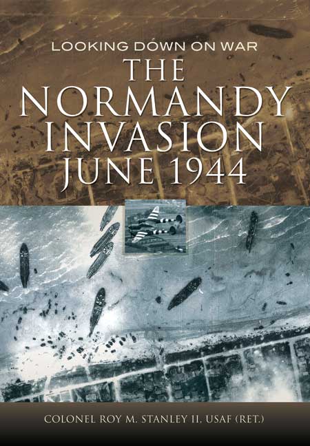
The Normandy Invasion literally takes a different view of D-Day and just beyond, showing the well-known events using aerial photos. This is what anxiously waiting senior officers knew about progress in the early hours of 6 June 1944. The RAF and USAAF imagery used is almost entirely from long dormant U.S. Department of Defence Intelligence files.
Examining the invasion scene beach-by-beach, the eyes of a trained, experienced photo interpreter uncover details a layman would certainly miss. This overview of Normandy landings and subsequent combat shows the scope and sweep of battle and helps explain why some objectives were reached, why some units forged ahead where others were stalled. We see the beaches as never before; their width at low tide; the support vessels off shore and equipment moving inland; formidable beach obstacles, and pre-invasion aerial reconnaissance.
Think of this book as an adjunct to all the ground-level photos you have seen of men leaving landing craft or crouching beside sea walls – a different perspective on one of the momentous military actions of the last hundred years. Refer to this book when you read about D-Day and actually see what other authors have written about.
Awesome book with ton of aerial reconnaissance pictures from during and right after the invasion.
FSAddOn.com
This is a truly fascinating book, with a collection of important pictures of the D-Day landings, supported by informative captions. A great addition to the literature on this famous battle.
History of War
This book takes an innovative approach to describing the much-trodden territory of the D-Day landings by using a very broad range of aerial photographs to tell the story of the invasion, from the reconnaissance flights over the Atlantic Wall during the planning stages to the assault itself, devoting a chapter to each of the beaches, Pointe du Hoc and the British and American airborne landings. What makes this book extraordinary is that its author was a former photographic interpreter and so is able to pick out innumerable details in the photographs which would otherwise be overlooked. Each are accompanied by notes which account for all that is going on within the picture, and by using a number of photographs in a sequence, or of the same scene taken later in the day, they describe phases of the attack as they unfolded and give a clear impression of the obstacles being faced by the troops on the ground.
www.pegasusarchive.org
This book takes an innovative approach to describing the much-trodden territory of the D-Day landings by using a very broad range of aerial photographs to tell the story of the invasion, from the reconnaissance flights over the Atlantic Wall during the planning stages to the assault itself, devoting a chapter to each of the beaches, Pointe du Hoc and the British and American airborne landings. What makes this book extraordinary is that its author was a former photographic interpreter and so is able to pick out innumerable details in the photographs which would otherwise be overlooked. Each are accompanied by notes which account for all that is going on within the picture, and by using a number of photographs in a sequence, or of the same scene taken later in the day, they describe phases of the attack as they unfolded and give a clear impression of the obstacles being faced by the troops on the ground.
pegasus Archive
This is a photo essay covering the greatest amphibious operation to take place in Europe. The title suggests that this is a collection of aerial photographs and there are many outstanding aerial photographs, but there are also clear maps and photographs taken from the ground.
aerospace.firetrench.com
Historically, authors have depended on D-Day images that were shot from the ground, with maps that include information from often several different sources. Aerial photographs are rarely used and this book is a very valuable addition to available photographic information already published. It provides a new perspective on the landings and subsequent actions in Normandy. As never before, the reader can gain a view of the scale of this amazing military information, both of the German defences and the Allied forces landing, being resupplied and breaking out from the beach heads. This is a book not to be missed.
I found this book to be very likeable and one of those casual dip affairs you can have a browse through over a cup of tea (other hot beverages are available) as and when it suits. The author has lifetime in photographic interpretation and brings his knowledge to bear. It’s a bit of fun. I just think it takes itself a tad too seriously. Maybe it’s me. I am not telling you to avoid it by any means – the book will fit snugly into your Overlord library, but it could be a bit of a luxury. If you are interested in photographic interpretation or want to see D-Day from a truly different perspective, then look no further. I love aerial photography, so it appealed to me on that level alone. I suspect I am sending you mixed messages here – but that is the effect this kind of book has and I have made my point.
War History Online
Lots of rarely seen and interesting photos of D-Day and the author uses his map interpretation skills to analyse the photos and events in an interesting and informative way. A highly recommended book for people interested in D-Day.
Amazon Review, Ghost24.
Looking Down On War: The Normandy Invasion is a must read for anyone interested in WWII History or more specifically the Normandy invasion. The book shows us the events of this part of WWII as it is not normally seen; from the air. This book is well laid out, the photographs are captivating and with Col. Stanly’s dialog explaining what we are seeing in the photos you will get lost in the history. Recommended!
Inscale
About Roy M Stanley
Colonel Roy M. Stanley II, USAF (retired), became an Aerial Photo Interpreter in 1959 and went on to assignments with the Defence Intelligence Agency, the Air Staff and in Japan, Thailand and Vietnam. Now retired after 27 years’ service he lives near Fredericksburg, Virginia. He has written seven books.


